19th International
CODATA Conference
Category: Environmental Informatics
Use of GIS
and Statistics for an Environmental Monitoring System in Germany
Gerlinde Knetsch (gerlinde.knetsch@uba.de),
Umweltbundesamt, Germany, http://www.umweltbudesamt.de
Winfried Schröder
(winfried.schroeder@ispa.uni-vechta.de),
Hochschule Vechta, Institut für Umweltwissenschaften, Germany, http://www.iuw.uni-vechta.de/personal/oekologie
1. Introduction
The purpose of environmental monitoring is to process the data generated by
monitoring programmes and measuring networks according to thematic and methodological
aspects, and to combine them in a cross-cutting way and assess them in the light
of the problem under investigation, in order to provide the information needed
for environmental policies. Statistical methods and simulation models are indispensable
tools for such processing and integration, enabling environmental monitoring
data to be linked in space and time. For this purpose, a multivariate statistical
procedure is used to aggregate areal data on climate, soil, orography and potentially
natural vegetation to ecoregions. The areal data and the results of this computation
are managed through a GIS. This ecoregionalisation
is used as a basis for the cartographic description, combined analysis and assessment
of different environmental monitoring networks. It can be used to describe representativity
in terms of landscape units, and as a spatial reference base for measuring data
following geostatistical verification of their extrapolability from the measuring
point to surrounding areas. Based on this geostatistical analysis of the representativity
of measuring data, and the determination of monitoring stations’
representativity of landscape structures by means of ecoregionalisation, proposals
can be formulated for the optimisation of monitoring networks.
2. Methods and Instruments
The multivariate statistical procedure CART (Classification and Regression Trees)
and the geographical information system ArcView / ArcInfo are used to divide
Germany into different ecoregions (landscapes and natural areas), based on two
criteria:
- homogeneity, i.e. the
elements within each class should be as similar as possible, and
- discrimination, the classes
(groups) should be as distinct as possible.
The following ecologically
significant site characteristics have been selected for the multivariate classification
of areas using CART:
3.
Presentation of results
The method produces an ecoregionalisation
on a comprehensible statistical basis while affording the largest possible degree
of user-independence, i.e. objectivity. The target variable “potentially natural
vegetation” is defined to be the ecological potential of an area which could be
expected under the present climatic, orographical and pedological conditions if
all human impacts are excluded. It thus describes a reference state that is important
in precaution-oriented environmental protection. When ecoregionalisation is used
in combination with environmental monitoring data which have been generalised,
where possible, to cover larger areas, these monitoring data can be interpreted
via the ecological elements which have been aggregated to ecoregions. The method
and the ecoregionalisation presented here validate the expert-knowledge-based
delineation of landscape units developed by Meynen and Schmidthüsen in 1962.
4.
Applications
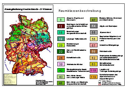
The result of the ecoregionalisation
is entered into a GIS and overlaid with maps
showing the distribution of measuring stations of different environmental monitoring
programmes. The measuring-network density can be calculated for each ecoregion.
Based on this, the representativity of the monitoring sites in relation to the
spatial landscape structure can be verified. This can be done in two ways: First,
by determining whether the distribution of the measuring stations is proportional
to the ecoregion area. Second, a neighbourhood analysis method developed by Vetter
and Maass (1994) allows the extended surroundings of the monitoring sites to be
included in the representativity considerations. Finally, by combining metadata
and network geometries, conclusions can be drawn with respect to geographical,
temporal and thematic characteristics of the measuring stations (identification
of geographical redundancies and gaps, possible need for harmonisation). The ecoregionalisation
of Germany offers
a basis for planning and development measures (optimisation, harmonisation, linkage)
in the fields of nature and landscape protection, forestry, environmental monitoring,
and for the identification of representative monitoring sites (Kothe and Schmidt
1994; Schröder et al. 1998). In addition to monitoring data analysis and the metadata,
ecoregionalisation constitutes a further module of an environmental monitoring
system for Germany.
It is currently being used for the designation of areas for monitoring the environmental
impacts of genetically modified organisms. References:
- Breimann et al. (1984):
Classification and regression trees (CART). - Monterey, Wadsworth, Inc.
- Knetsch, G. (2000): Raumbezug
in der Umweltbeobachtung des Bundes und der Länder, UWSF 12 (4), p. 235
- Kothe, P., Schmidt, R.
(1994): Nachbarschaftsanalytische Ausweisung repräsentativer Bodendauerbeobachtungsflächen.
In: Schröder, W. et al. (Eds..) Neuere statistische Verfahren und Modellbildung
in der Geoökologie. - Braunschweig, Wiesbaden, pp. 95 - 101
- Mertens et al. (2002):
GIS-based regionalization of soil profiles
with Classification and Regression Trees (CART). In: Journal of Plant Nutrition
and Soil Science, Vol. 165 (1), pp. 39 – 43
- Meynen, E. et al. (1962):
Handbuch der naturräumlichen Gliederung Deutschland. – Bad Godesberg
- Schröder, W. et al. (1998):
Organisation und Methodik des Bodenmonitoring. - Berlin (UBA-Texte 21 / 98)
- Schröder, W. et al. (2001):
Konkretisierung des Umweltbeobachtungsprogramms im Rahmen eines Stufenkonzeptes
der Umweltbeobachtung des Bundes und der Länder. - Berlin (UFOPLAN 2000, FKZ
299 82 212/01 und 02)
- Schröder, W.; Schmidt,
G. (2001): Defining ecoregions as framework for the assessment of ecological
monitoring networke in Germany
by means of GIS and classification and
regression trees (CART). In: Gate to EHS 2001, pp. 1 – 9
- Schröder, W. et al. (2002):
Harmonisierung der Umweltbeobachtung. Instrumente zur Prüfung methodischer
Vergleichbarkeit und räumlicher Repräsentanz. In: Fränzle, O. et al. (Hrsg.):
Handbuch der Umweltwissenschaften. Grundlagen und Anwendungen der Ökosystemforschung.
- Landsberg am Lech, Chapter V-1.3 (8. Erg.Lfg.)
- Vetter, L., Maass, R.
(1994): Nachbarschaftsanalytische Verfahren. In: Schröder, W. et al. (eds.)
Neuere statistische Verfahren und Modellbildung in der Geoökologie. - Braunschweig,
Wiesbaden, pp. 225 - 237