T. Todd Elvins
San Diego Supercomputer Center
University of California, San Diego
todd@acm.org
Introduction
Decision-makers, such as city planners and corporate executives, often rely on trained computer specialists to perform and analyze what-if scenarios. Reliance on a computer specialist to access digital information precludes the decision-maker from knowing all the possible operations and hence from considering all possible decision outcomes. In the same way that spread-sheet programs enable company officers to try what-if scenarios without enlisting an accountant, decision-makers should visually access internet/intranet-based digital information without enlisting an information liaison. To enable such independent interaction, user interfaces must offer affordances for: (1) integrating 3D thematic layers, such as elevation maps, 3D simulation data, and landmarks, into browsable virtual worlds; and (2) wayfinding in virtual worlds.
Desktop virtual environments: information integration
One San Diego Bay Project (http://www.sdsc.edu/sdbay) goal is to enable decision-makers to explore and analyze bay-related 3D data layers selected from a web-based data repository. While information liaisons often utilize geographic information systems (GIS) for integrating thematic information layers, decision makers cannot use GIS for a number of reasons: (1) GIS are difficult to use, often requiring months of training, (2) GIS usually handle only 2D thematic layers, and (3) few GIS can interact with web-based information repositories.
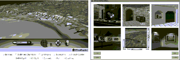
We have built an experimental 3D GIS-like system based on VRML-formatted data. In our data repository each thematic data layer is represented as 3D geometry in a separate VRML file. To composite a subset of these thematic layers into a virtual world, we have developed Java applets, based on the VRML External Authoring Interface, that run concurrently with the CosmoPlayer VRML browser. An example session is shown in Figure 1a.
Desktop virtual environments: information navigation
Wayfinding is "the ability to find a way to a particular location in an expedient manner and to recognize the destination when reached" [1]. People find their way in an environment using survey (bird's eye), procedural (route), and landmark (distinctive feature) knowledge. Each type of knowledge helps the world visitor construct a cognitive map of a region and thereafter navigate using that map [2]. Landmarks are critical in making an environment legible and allowing a visitor to build a cognitive map.
We have designed and implemented a 3D thumbnail affordance for virtual world wayfinding that we call a worldlet [3]. A worldlet is associated with a viewing position and orientation, and captures a snapshot of the 3D shapes (usually landmarks) falling with the viewpoint's viewing volume. Worldlets can be explored and manipulated in the same way that virtual worlds can be explored and manipulated. Incorporated into a VRML browser, albums of worldlets allow a world visitor to select destinations of interest, navigate unfamiliar worlds, and build survey, procedural, and landmark knowledge. Figure 1b shows an album of worldlets. Frustum and spherical worldlets can be browsed in a menu, or overlayed atop the full world in a contrasting color. Usage of landmarks represented in worldlets falls into two main categories:
A pilot study was conducted to evaluate the effectiveness of a worldlet guidebook in locating a sequence of landmarks leading to a goal. Guidebook entries providing landmark descriptions were offered in three ways: in textual form, as 2D images, and as 3D worldlets. The five subjects visited three cities in a random order. ANOVA statistical analysis showed that using worldlets significantly reduced travel time and distance enroute to the goal.
Figure 1: (a) Java-enhanced VRML, and (b) an album of 3D worldlets.
Summary
Java-enhanced VRML worlds enable world visitors to mix and match an arbitrary collection of 3D thematic layers. Worldlet guidebooks and albums facilitate wayfinding in virtual environments by providing manipulatable 3D landmark representations, and thus enabling a visitor to form a more complete cognitive map. We feel that the field of information visualization will benefit as emerging technologies, such as the data visualization and human-computer interaction techniques presented here, are gradually adopted and adapted. We are at the beginning of the information age, we know little about how humans interact with digital information, and we must take advantage of insights gained in related fields.
References
[1] John Peponis, Craig Zimring, Yoon K. Choi. Finding the Building in Wayfinding, Environment and Behavior, 1990, 22 (5), 555-590.
[2] Kevin Lynch. The Image of the City, M.I.T. Press, 1960.
[3] T. Todd Elvins, David R. Nadeau. Worldlets - 3D thumbnails for wayfinding in virtual environments. Submitted for publication.